


NOGGIN
Ground Penetrating Radar (GPR)
Adaptable, High-performance GPR
If you need a high-performance, configurable GPR that is adaptable for multiple applications, the NOGGIN® is the right choice for you.
The NOGGIN has sensors ranging from 1000 MHz to 100 MHz. Simply choose the sensor that provides the depth penetration and resolution best suited for your application.
Noggins can be used for high resolution surveys of concrete buildings and structures, bridge decks, pavement, runways and underground mines: for moderate-depth surveys such as subsurface utility mapping, underground storage tank detection, archaeology, forensics and unexploded ordnance; and for greater depths to map geologic structures, measure depth to bedrock, glacier profiling and perform geotechnical surveys.
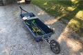
The NOGGIN family provides 5 configurations to adapt your GPR data collection to any terrain.
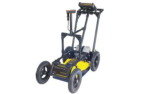
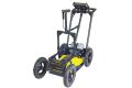
- SmartCart® - durable, 4-wheeled, folding cart for fast, efficient data acquisition over smooth to moderately rough terrain.
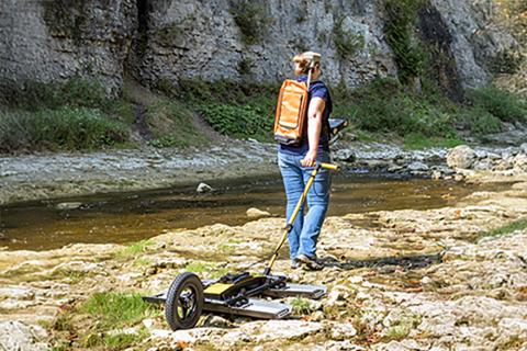
- SmartTow™ - designed for hand-tow surveys over smooth to rough terrain, such as grassy, brush covered or rocky surfaces.
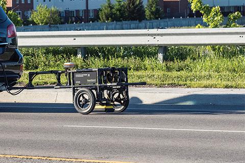
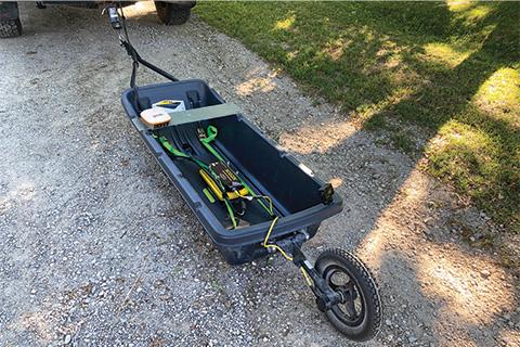
- SmartSled™ - designed for vehicle-towed surveying over smooth to rough open terrain, such as agricultural fields, grass, gravel roads or rocky surfaces.
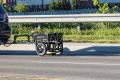
- SmartChariot™ - designed for vehicle-towed surveys covering large, smooth, open areas, such as roads, bridges, large parking lots and garages, and open fields like golf courses and parks.
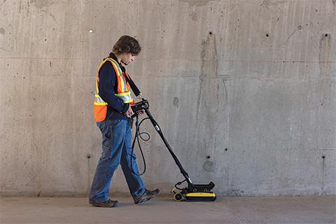
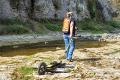
- SmartHandle™ - designed for pushing or pulling the Noggin over a smooth terrain. Light & compact for vertical or overhead surveys, and surveys in confined spaces.
Available in four center frequencies and five standard configurations, NOGGIN systems are field-proven for use in many environments across many applications.
NOGGIN systems provide flexible data collection options and powerful in-field visualization of your GPR results. Data can be exported to the EKKO_Project GPR Software for further analysis and reporting.
Noggin GPRs are used by researchers and practitioners to collect high quality data for a wide range of subsurface applications in challenging environments worldwide - from the equator to polar regions.
Noggin sensors and configurations allow you to mix and match to build the GPR system that works for your specific application, and easily reconfigure a different deployment method for another application. Choose the combination of center frequency and configuration best suited to your application and terrain.
User-friendly interface allows you to quickly scan lines or grids with flexible collection settings, interpret targets in real-time with color field interpretations and visualize grid scans with in-field depth slicing.
Viewing cross-section data and the map together helps users interpret subsurface responses in relation to their location. Mark targets by touching the screen and tracking their path on the map. The SplitView feature requires an external GNSS.
DynaQ® technology adjusts stacking based on collection speed to optimize data quality. It supports up to 2,048 stacks on Noggin 100/250/500/1000 systems and up to 65,536 stacks on the Noggin Ultra 100.
Enables the use of GPR in applications requiring different data collection methods - use an odometer to trigger at a set distance, use free run in speed or time when an odometer is not suitable, (e.g on ice or water), or manually press a button to collect data.
For deeper surveys, the Noggin Ultra 100 provides an enhanced signal-to-noise ratio, enabling the detection of weaker GPR signals at greater depths.
Add high-accuracy positioning and mapping to your GPR data.
Integrate GPR results into your preferred mapping solution.
The GPR-SG package is available as an accessory.